Planning: The Thought Process
Originally Published in Southeastern Rider Magazine, May 2017
When you are laying out a potential route for a motorcycle, there is a lot you don’t know. There might be a place that you have heard a lot of bikers talk about, or more than likely a stretch of curvy road, that you might want to explore. If you are riding into unknown territory, your plan could lead you onto some asphalt ribbons lined with great scenery, or onto some stretches that makes you wonder who decided this was a road.
Hopefully, the easiest part of a trip is the starting point. If you don’t know where you are, you are going to have a hard getting to where you want to go. The second easiest pick will probably be your destination. It’s real easy if you are planning a loop, since the start and end are the same place. Point A and Point B, well that’s it for a lot of people. They don’t have a care for what’s in between. For those of us on two wheels, we often seek the longest distance between two points, so our trips start at Point A, and may go to Point Z and beyond.
 |
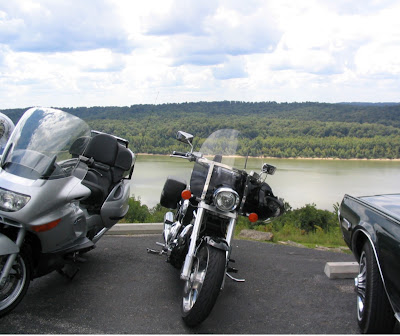
| My Honda VTX 1800 sits next to my father's BMW perched above the Ohio River in Leavenworth, Indiana. |
It’s not about getting there early. In fact, we will probably be late. Besides enjoying the wind, I know a lot of bikers can elongate a trip that would make Clark Griswald look like an amateur, while he stares at the world’s second largest ball of twine.
If you don’t have a destination, and just want to ride somewhere a few hours, or a tankful away, some Navigation Software can create a “Drive Time Zone”. This will create an area you can reach based on the time or distance you entered. I have used this several times in Microsoft’s Streets and Trips.
The next part is a bit more challenging. More and more GPS Units and Planning Software are adding the option of a “Scenic Route”. People have always asked me about this, and I always wondered how you use logic to select something scenic?
Here is an example of my thinking, using the National By-Ways Program. I would guess that an application would pick these routes on this list, as they are listed as scenic by the federal government. So if you were in Louisville, Kentucky, and wanted to ride across Southern Indiana, which is an area I have explored, it would put you on Interstate 64, a road listed on the National By-Ways Program. However, there is a more scenic, and motorcycle friendly, stretch of asphalt with the same number, but it is designated Indiana State Highway 64.
Zoom in a bit closer, and scroll your map south, and you will see Indiana State Road 66. This little stretch with the famous road number, hugs the Ohio River. Now this is a scenic drive. Another hint if you are in the area, stop for a meal, or an overnight stay, and the Overlook Inn at Leavenworth, Indiana.
 |
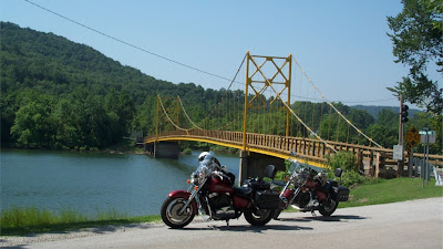
| The Bridge of Nostalgia in Beaver, Arkansas serves as the backdrop for Two Honda Shadow Sabres, the one in front is mine. Waterways usually offer a scenic and meandering route. |
One of the first thing I do with a new GPS or navigational application, is look through the settings, and adjust it to shortest distance, barring there is no option for most scenic. This may sound like it’s against my, and virtually any other rider’s principles, but it actually is better option than shortest time. The shortest distance often take more time, which means more time in the saddle. I will also set to reduce the use of Interstates and Freeways. While we’re here, it’s a good rule is to avoid any road with an “I” or Interstate in its name.
So my second step, after drawing a line from start to finish, is to zoom in on the map, and start looking for good stretches of back roads. The more squiggly, the better for me. Experience will be a key when it comes to finding the better road choice. Go with your gut feeling. Let me just give you a warning: stay away from roads with names like “Skidmore” “Meat House Row” and “Monkey Run”. While you will be fine if you are on an adventure bike, being two up, on a loaded down, half ton, cruiser on these “roads” is a workout for your pucker muscle.
Satellites images of the route can help you stay on pavement. The imagery has gotten really good over the years, even in areas less traveled, that you can often tell if a road is paved.
While I’m looking to drag my route away from roads that may be heavily traveled by cages, I also look for amusements along the way. Parks, forests and other roadside attractions, like the aforementioned record setting ball of twine, can be great places for a stretch break. Often, these roadside attractions have some great roads leading to them.
Nature rarely does anything straight, so waterways weave back and forth as if they have no destination, or no need to get anywhere. Sounds like great planning to me! When roads run along streams, creeks and rivers, they have to curve to and fro, also. Most waterways is also good eye candy. A plus can be that you might find a crossing that is an adventure for your skill and your eyes.
Whether you are heading out for a day ride, or for a longer trip, you will need to stop for fuel, food, and breaks to answer nature’s ringing bell. When my brother and I first started out taking trips, we would run until the tank was nearly empty, and give our bodies a break while re-fueling. This meant 120 to 150 mile stretches, or three to four hours in the saddle. On a trip out to Virginia, we rode out this way. On the way back, we decided to take more breaks, every 60 to 65 miles, or an hour and half. We made more miles in less time by stopping more. What we found out was that the extra stops were shorter, as we didn’t need to walk off all that monkey butt. At the end of the day, we didn’t find ourselves completely drained, and only wanting to walk to the closest eatery. The moral of the story: plan more stops than you think you will need, when you are out on your trip, there is no rule that says you have to stop.
My final advice? You’re out on the road on two wheels for the adventure. You are taking the trip to find and see new things. Sights, sounds, smells, and the feel of the wind should not be the only new experiences. Treat your taste buds, too! The rule here? Don’t eat at a chain restaurant unless you absolutely, positively have to. I have been pretty lucky, taking the risk of sitting down at a table I know nothing about, and was rewarded with some of the best meals I have ever had. Something I have noticed, if the owner is either serving, cooking or greeting, there is a good chance the food is going to be good.
Yes, I have had my share of sub par fare also, but good food or not, I often leave with an interesting story or two about the local area. Once on a trip through Michigan, I had the Mom, of a Mom & Pop Eatery, try to set me up with her daughter!
Planning a great trip is one of those things that science and logic can only take you so far. Then the art comes in by picking routes off the beaten path. It could also include drives through parks, forests, or by other oddities that are out there. Small towns on small roads will also feature small cafes that you won’t see ads of happy, sated people on television.
When you are out on the road, remember that just because you have a plan, doesn’t mean you have to follow it. Even with hours of planning, I have still strayed from my line and found some great roads.
To read more of my motorcycle stories, you can check out my Motorcycle Blog at www.Blogspot.RodneysMCBlog.com
Comments